The topography of Rajasthan is varied, with a significant portion of the state being parched and dusty. The varied topography includes rocky hills, rolling sand dunes, wetlands, thorny scrubs, river-drained plains, plateaus, ravines, and wooded areas.
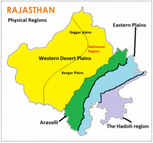
Rajasthan is divided into four main physiographic regions:
- The Western plain
The western plain covers the largest part of the state across the districts of Hanumangarh, Ganganagar, Bikaner, Jaisalmer, Barmer, Jalore, Sirohi, Palo, Jodhpur, Nagaur, Churu, Sikar & Jhunjhunu.
- The Aravalli Range
The Aravalli Range runs approximately 692 km in the southwest direction through the districts of Jaipur, Sikar, Khetri, Alwar, & Sawai Madhopur.
- The Eastern Plains
The area on the northeast, east and, southeast of the Aravalli range is known as the Eastern Plains of Rajasthan. It covers an area of about 23.3% of the state. It is spread across the districts of Tonk, Ajmer, Bhilwara, Chittorgarh, Bharatpur.
- The south-eastern plains or Hadoti Plateau
The south-eastern plains or Hadoti Plateau contains about 9.6% of the area of Rajasthan across districts of Bundi, Kota & Karauli.